Five hours of flight time today, heading northwest over Kongsfjorden with the primary objective of investigating the spatial variability of precipitation in Kongsfjorden. Off the coast of Spitsbergen, there was a distinct convergence line with significant precipitation, which was also predicted very well by the model. This line was very stationary; two flyovers yielded very similar measurement data.
We reached the sea ice edge, which we were also able to observe from the plane due to the presence of only low-level clouds.
What made yesterday’s flight special was the close coordination with the AWIPEV station in Ny-Ålesund. This allowed us to observe the same clouds both from above (from the aircraft) and from below (from the ground station). These dual measurements are crucial for testing and validating our assumptions about the attenuation of radar signals.
By coordinating dropsondes from Polar 5 and radiosondes from Ny-Ålesund, we were also able to observe katabatic winds in Kongsfjorden, as significant differences in the data were evident here. Katabatic winds are cold winds that flow down from higher elevations and often occur in polar regions. Due to the complex weather conditions, today was entirely devoted to planning for tomorrow. Then it’s all about: LEADS, LEADS, LEADS! We’re excited to see if we can carry out our plan tomorrow.
We’re back, and a lot has happened in the last few days. On March 26 and 27, we had two more research flights: a shorter flight over the northerly stream across the Fram Strait to capture the cloud streets, and another Cold Air Outbreak flight, including a rendezvous with EarthCARE. This means we can proudly and happily look back on eight successful research flights in the first half of the campaign.
Over the weekend, the new researchers for Part 2 of COMPEX gradually arrived in Longyearbyen, which also meant saying goodbye to many from the first part. We celebrated this with pizza, billiards, table soccer, and board games on Sunday evening.
Starting the new week, we had another flight today with a new crew heading west over the open ocean. There, we found predicted low-level clouds and wonderful views from Polar 5, so everyone returned with a big smile.
A cute Arctic fox wished us a good night and a good flight tomorrow, during which we’ll be flying over Ny-Ålesund and Kongsfjorden again. Stay tuned!
Time for a bit of a catch up. Wednesday the 18th brought some unfavourable weather for flying. We took the opportunity to plan for another flight and start with some data management. Models were showing that low level clouds would be widespread and persistent to the west of Svalbard on Thursday, with a window of opportunity to capture some of these clouds before a slow moving low pressure system brought in mid to high level clouds. During the flight out there were thick low-level clouds over the open ocean, which thinned significantly over the sea ice, showing only very weak reflections in the radar. On the way back in to Longyearbyen, low-level clouds were filling the Kongsfjorden, next to Ny-Ålesund, brought in from the west. We were fortunate to be able to fly a pattern over this somewhat rare occurrence and drop some sondes to profile the clouds, making the crew very happy!
Snowfall was forecast for Friday, and the influence of a low pressure system made conditions unsuitable for flying. It was therefore declared that Friday would be a well deserved day off! During the day, we hiked up the Larsbreen to an ice cave under the glacier! The fresh snowfall was very welcome, and permitted some great sliding on the way back to Longyearbyen.
More unsettled weather on Saturday has made for another day off from flying, but we are taking it as a data and planning day. Cold air outbreak conditions are developing to the west of Svalbard, which look to be stable for the coming week. Mid-level clouds may prevent us from flying on Sunday, but we will wait until later in the day to make this decision. So for now we are keeping an eye on the forecasts and crunching the data that we have collected so far.
As we reported earlier in this blog, we participated in the airborne field campaign HALO-(AC)³ In March and April 2022. The goal of the campaign was to improve the understanding of the airmasses transformation when transported into or out of the Arctic. Two types of airmass transports were of particular interest: First, moist and warm air intrusions that transport high amounts of heat and moisture from the mid-latitudes into the Arctic. Second, marine cold air outbreaks that lead to the formation of cloud streets and convective cells when cold and dry air from the central Arctic is transported southwards over the relatively warm North Atlantic. In our study, we analyse the weather (and sea ice) conditions during the HALO-(AC)³ campaign.
Map of the study area of the HALO-(AC)³ campaign including the flight tracks of the research aircraft HALO, Polar 5 (P5) and Polar 6 (P6). The study area has been separated into three subregions.
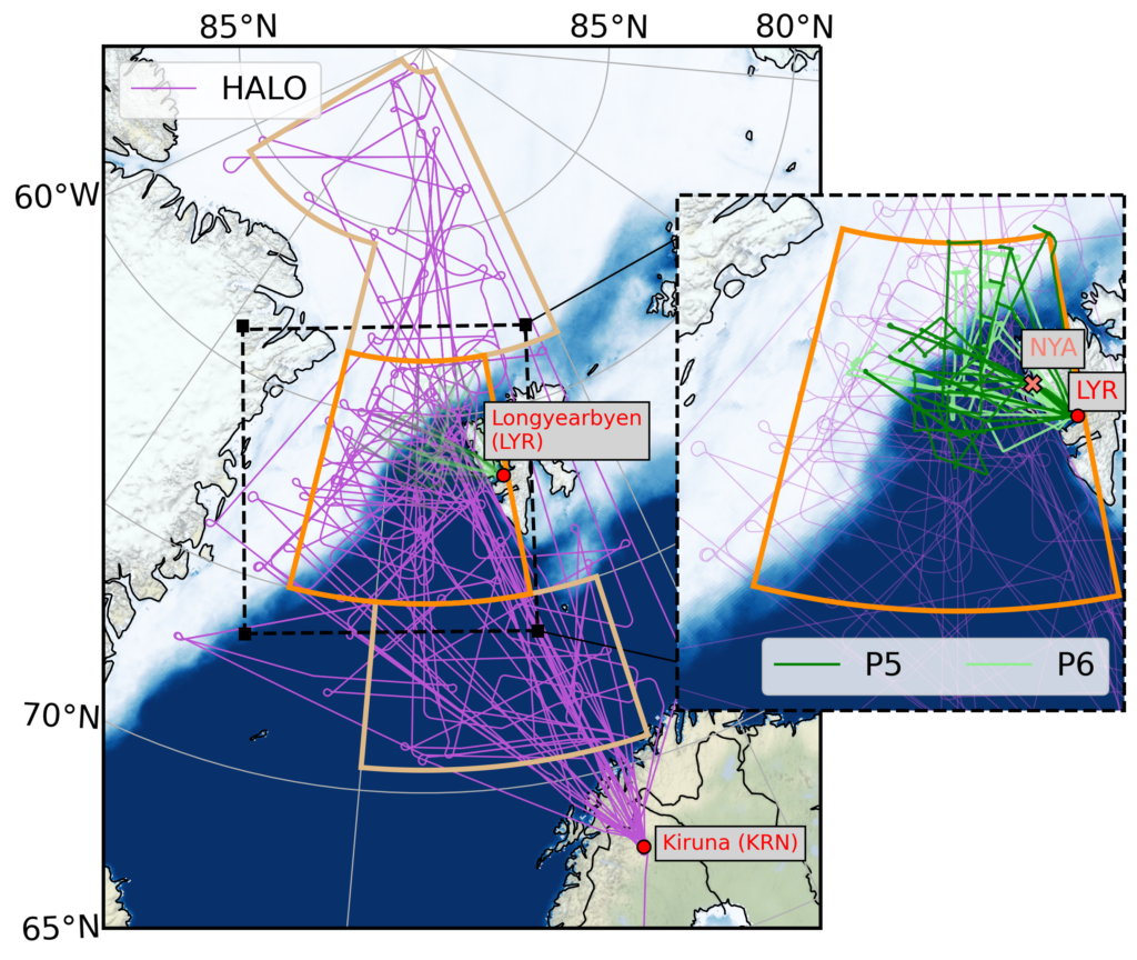
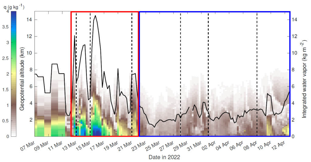
We separated the campaign into a warm and a cold period with the help of northwards humidity transport (IVT) and the so-called cold air outbreak index (MCAO index). The cold air outbreak indicates the strength of the temperature difference between the surface and the lower atmosphere. High differences suggest cold air outbreak conditions with strong interactions between the cold ocean and the atmosphere. The warm period was dominated by northward winds and warm air intrusions while the cold period featured several cold air outbreaks.
(a) Northward water vapour transport (IVTnorth) and (b) marine cold air outbreak (MCAO) index for the campaign duration in 2022 (black line). Grey shading indicates the climatology over the years 1979-2022. The red box shows the warm period, while the blue box illustrates the cold period.
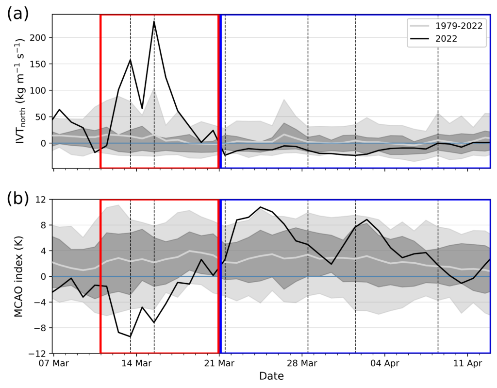
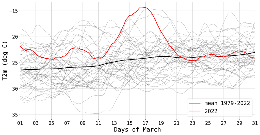
During an extremely strong warm air intrusion, record breaking near-surface temperatures occurred in the central Arctic compared to the March 1979-2022 climatology. Also at Ny-Ålesund, the weather station recorded the highest near-surface temperatures for March since the beginning of the measurements in 1975. This warm air intrusion was detected as so-called Atmospheric River, a thin but long band of extremely strong moisture transport. Over the sea ice northwest of Svalbard, record breaking rainfall rates occurred.
Average 2 m temperature in March 2022 north of 80°N (red line). Thin black lines show the temperature for each year between 1979 and 2022 and the thick black line illustrates the average over those years.
At the beginning of the cold period, a strong cold air outbreak led to an extremely dry atmosphere over Ny-Ålesund with integrated water vapour content of just 1.1 kg m-2 (24 March 2022). Less than 3 % of all radiosondes launched since 1993 recorded drier conditions.
Humidity measurements from radiosondes (weather balloons) launched at Ny-Ålesund (Svalbard) during HALO-(AC)³. The colours indicate the specific humidity (fraction of water vapour mass to total air mass) while the black line shows the total humidity content of the troposphere (lowest layer of the atmosphere).
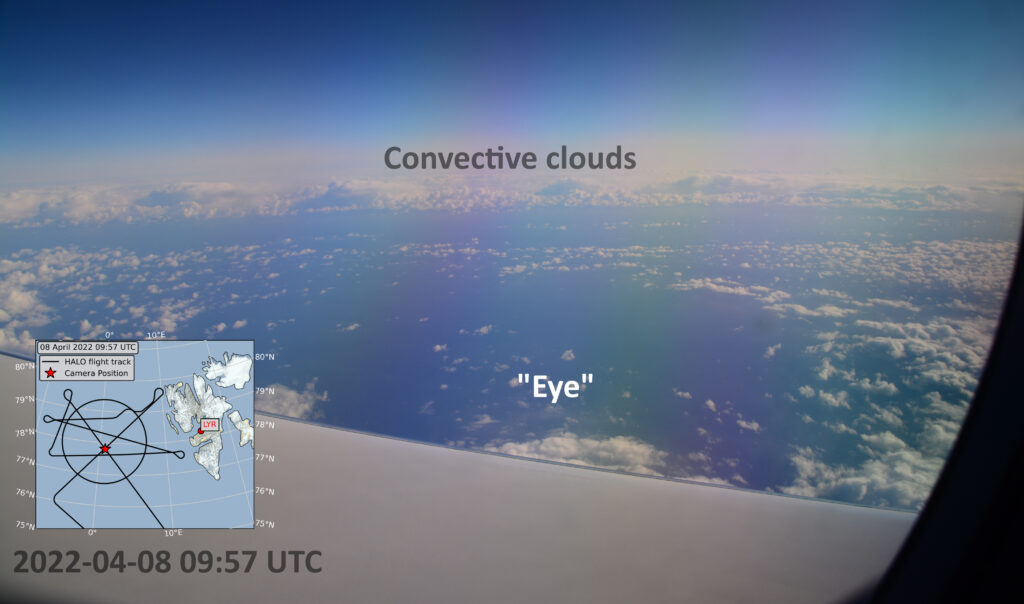
During the cold period, we also observed the Arctic version of a hurricane, a Polar Low. Polar Lows are characterised by convective (cumulus) clouds, relatively strong winds (at least gale force) and precipitation, while extending only over a few 100 kilometers. They also have a relatively cloud free centre like the eye of a hurricane. We analysed the environmental conditions for the formation of the Polar Low.
Photo taken from the research aircraft HALO during the flight to observe the Polar Low.
Luckily, the weather conditions were quite favourable to achieve the goals of the campaign because we could capture both types of airmass exchange between mid-latitudes and the Arctic. The publication has been submitted to the European Geosciences Union journal Atmospheric Chemistry and Physics.
This week Mario and myself traveled to Ny-Ålesund, Svalbard, to exchange our cloud radar MiRAC-A with the cloud radar JOYRAD94. Since MiRAC-A is needed for campaign preparations, it has to travel back to Germany. Swapping the instruments on the roof of the atmospheric observatory of AWIPEV (https://www.awipev.eu/) went very smoothly.
Crane operation to lift the cloud radar JOYRAD94 on top of the AWIPEV atmospheric observatory
Thanks also to the AWIPEV and Kingsbay support! What a wonderful place to do measurements!
In December, Kerstin was interviewed by a journalist in the local newspaper “Kölnische Rundschau”. The article (in German) about climate change in the Arctic and about our measurement activities in the Arctic, in particular at AWIPEV (Ny-Ålesund, Svalbard), was published on Dec 27, 2022.
What is it about?
The article highlights the importance of long-term data and data analysis for climate studies. It is always great to have the chance to communicate our science to the broader public! And of course it is a challenge as well…
Far in the North on Svalbard at the AWIPEV research station in Ny-Ålesund, the Institute for Geophysics and Meteorology operates a set of cloud remote sensing instruments in the framework of the (AC)3 DFG program. The idea of setting up instruments that far in the North is to learn more about Arctic clouds, like their structure, lifetime, or the role they play in the dramatic change of Arctic climate. A key instrument of the setup is a cloud radar measuring at 94 GHz. Such a cloud radar shows the vertical structure of Arctic clouds by measuring the reflected signal send upwards in different levels (radar reflectivity).
The intensity of the reflected signal depends thereby on the size, amount, and shape of cloud and precipitation particles (hydrometeors) found in the atmosphere. Easily speaking, the more red the color the thicker the cloud or the more precipitation is present. In addition to the radar reflectivity, the cloud radar can measure the vertical motion of the hydrometeors and by that where up- or downward motion is present or distinct between clouds and precipitation.
During the last three years, JOYRAD94 has done a perfect job in Svalbard. But now it is time for some maintenance at the manufacturer. Therefore it needs to be de-installed, packed and shipped back to Germany. To do that, a team from our institute has traveled to the Arctic for two weeks. Since we definitely do not want to be without cloud radar measurements, our second cloud radar MiRAC-A, usually operated onboard the Polar 5 aircraft, has been shipped up there and will take over JOYRAD94’s job. So today a huge crane took JOYRAD94 from the roof of the AWIPEV observatory building and lifted up MiRAC-A. It can make you quite nervous to see several hundred thousand euros hanging on four ropes. But the crane driver was a genius and it all went smoothly. After a bit of screwing, drilling, fixing, and configuring, MiRAC-A was set up and continued the important job JOYRAD94 did the last years – collecting data on Arctic clouds.